Geological history
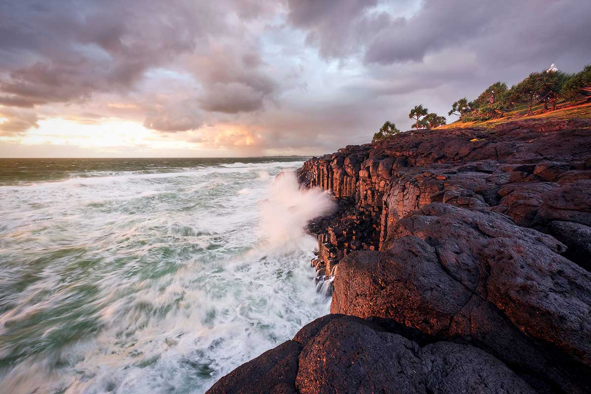
Fingal Headland. Photographer Ryan Fowler.
The scenic Tweed Valley lies in the far north-eastern corner of NSW.
Geologically it takes the form of a huge erosion caldera centred on Mount Warning, the sacred mountain that the original Aboriginal inhabitants have known for thousands of years as Wollumbin.
Volcanic activity
During the Miocene epoch between 20 and 24 million years ago, the Indo-Australian tectonic plate upon which the Australian continent sits was moving northwards, and it passed over a hot spot deep below the earth’s crust. This led to a period of volcanic activity during which a chain of volcanoes erupted along the coast of eastern Australia, extending from the Atherton Tableland in North Queensland to Victoria.
Some 23 million years ago the Tweed volcano erupted in northern NSW, pouring basalt lavas over the ancient land surface composed of metamorphic and sedimentary rocks, part of the Beenleigh Block and the Clarence Moreton Basin. The Beenleigh Block formed between 360 and 240 million years ago and the Clarence-Moreton Basin between 22 and 130 million years ago.
Over a period of 3 million years, a vast dome shaped shield volcano was formed, towering over 2 km above sea level and stretching from Lismore in the south to Tamborine in what is now Queensland to the north.
Three main series of lava flows occurred during this period at irregular intervals, some the result of violent eruptions, and others more gentle flows. The first group of lava flows produced what are known as the Beechmont basalts to the north and the Lismore basalts in the south; the remnants of these flows can be seen in the lower terraces on the southern side of the Springbrook plateau, and on the caps of the low coastal hills.
At Fingal Headland, the flows cooled to form columnar basalt, with distinctive hexagonal columns at right angles to the line of lava flow. This type of landform occurs in many other parts of the world, notably in County Antrim in Ireland and the isle of Staffa off the coast of Scotland, where the original Giant’s Causeway and Fingal’s Cave are found.
The second phase of eruptions was more violent. The volcano ejected rhyolites, volcanic glass, agglomerates and lighter ash, pumice and mudflows. The volcanic ash layers solidified to form tuff. The predominant rocks formed from this phase were rhyolite lavas. As rhyolites are extremely resistant to erosion, deep gorges were formed. They can be seen today on the upper Coomera River in the Lamington National Park and along the cliffs of Springbrook with spectacular waterfalls at their heads plunging from the plateau above. They form cliffs at Sphinx Rock in the Nightcap Range and at Springbrook. Binna Burra to the north was the centre of a large satellite eruption zone, and a similar formation in the south occurs in the Nimbin rhyolite.
The final phase of volcanic activity was a series of relatively quiet basalt flows, called Blue Knob and Hobwee basalts. They form a capping on the high plateaux that ring the caldera: the Nightcap Range to the south, the Tweed and McPherson Ranges to the west and the Lamington and Springbrook plateaux to the north. As the continent slowly moved off the hot spot beneath the earth’s surface, volcanic activity died down and the lava flows became fewer and more sporadic.
The work of wind, water and rain over millions of years eroded the volcanic shield; a myriad of streams flowed in a radial pattern and cut through the Blue Knob basalts, gradually forming gorges and waterfalls in the rhyolite layers.
Tweed River
The Tweed River, the other dominant feature of the Tweed Valley today, cut most quickly into the shield because it drained directly to the sea, received high rainfall and had the steepest gradient. After the period of volcanic activity ceased, vegetation gradually returned.
The high rainfall and warm subtropical climate of the Miocene Epoch fostered the development of luxuriant rainforest, and as Australia dried out during the late Miocene and Pliocene, sclerophyll forests, woodlands and coastal heath evolved. The distinctive pinnacle of Mount Warning (Wollumbin) is the central core of the ancient shield volcano.
Encircling the caldera are the Lamington and Springbrook plateaux in the north, the McPherson and Tweed Ranges in the west and north-west, and the Nightcap Range in the south, all remnants of the ancient volcanic shield. Although individually called a range, the Tweed, McPherson and Nightcap Ranges are each in fact a complex network of steep ridges and valleys radiating out from what was once the centre of the Tweed shield volcano.
The steep escarpments of the McPherson Range form part of the border between NSW and Queensland. The Pacific Ocean bounds the valley to the east. Other reminders of the Tweed Valley’s volcanic past are secondary vents and dykes exposed by erosion, such as the Pinnacle and Dinsey Rock. The rich volcanic soils created during the complex geological history of the Tweed caldera form the basis of the agricultural industries of the Tweed today, based on sugar cane, bananas, other subtropical fruit crops and cattle rearing.
To explore the geological history of the Tweed in more detail, visit Tweed Regional Museum Murwillumbah's Land | Life | Culture exhibition.
Extract from Australian Geographic #91 Jul-Sep 2008
Blasts from the past
 For the past 30 million years, Australia has been at the mercy of continental drift and colossal forces from deep within the earth.
As with all continents, Australia is on the move. Every year our slice of the earth's crust creeps north by about 7cm. Since Gondwana parted company we've shunted closer to the equator by some 37 degrees of latitude - more than one full length of the country. On the way, Australia passed over the top of a heat plume rising from deep within the earth's mantle - otherwise known as a hotspot. Like a blowtorch under a giant meat pie, this plume forced magma up through crustal weaknesses. As the continent edged northward, a chain of volcanoes arose one by one down the length of eastern Australia. The Tweed Volcano was the mightiest link in the chain, creating a life raft of fertile land for Gondwanan plants and animals.
Offshore eruptions
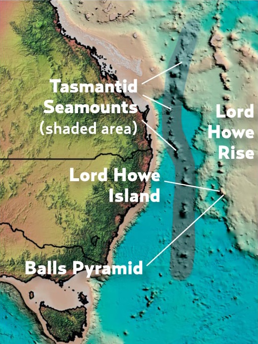
Australia's mainland volcanic chain has oceanic counterparts, including the Tasmantid Seamounts and the largely submerged Lord Howe Volcano.
Massive milestones
A succession of shield volcanoes from northern Queensland to central Victoria signpost Australia's slow, northward passage.
Where is the hotspot now?
Australia's hotspot - one of about 100 around the globe - currently lies beneath Bass Strait, at a latitude of 40 degrees south. Minor earthquakes and deep gas discharges are possible indicators of hotspot activity, though there are no signs of imminent eruptions.
Continental volcanoes
The action began 34 mya with eruptions of the Hillsborough Volcano, 45km north-east of present-day Mackay, Queensland. During the next 28 million years some 15 central or shield volcanoes formed along the eastern flank of Australia, with the last major fount bubbling to life and creating Mt Macedon just north of Melbourne.
Plumes and plates
While hotspot plumes remain more or less stationary within the mantle layer, the earth's crustal plates are on the go. The world's most violent volcanic regions are located close to the margins, where these massive plates are separating or colliding. In contrast, hotspot volcanoes such as those in Australia can arise far from these boundaries.
As Australia's plate shifted northward, a new shield volcano formed over the plume, while its predecessors, robbed of a magma source, drifted into extinction.
Lava dome to forest haven
Like a phoenix rising from the ashes, the verdant beauty of the Tweed Shire emerged from the hellfire and brimstone of the Tweed Volcano.
23 million years ago
Shield formation
In fits and starts over a period of some three million years, flows of basalt, rhyolite and other erupting volcanic material accumulate to form the Tweed Volcano's colossal shield structure - rising 2km above sea level and spanning nearly 100km in diameter.
15 million years ago
Weathering time
The Tweed Volcano draws rain-bearing clouds to its dormant bulk. Streams cut into the volcano's flanks to form radiating river gorges, exposing cliffs of the basalt and rhyolite lavas. Erosion is most rapid and severe along the high-rainfall eastern side.
Present day
Introducing the tweed
While remnants of basalt flows still lie beneath the eroded flanks of the volcano, its heart has been stripped bare, leaving the tough, crystalline rocks of its vents and magma chambers exposed as Mt Warning/Wollumbin.
Rivers of fire
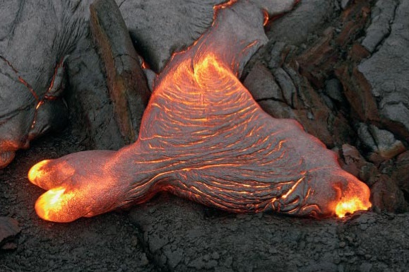 The power of lava
The Tweed Volcano's initial and final phases were dominated by mineral-rich basalt that bubbled to the surface at more than 1000°C and spread across large areas to create the volcano's gently sloping shield. Between these phases came fiercer eruptions of rhyolite, which welled up in the main chamber and other vents to produce pressurised explosions of gas, lava, rock fragments and ash - the latter forming beds of soft rock called tuff.